I had always been interested in spirituality, so I decided to take a
year-long journey to India to explore various religious practices and
traditions.
Budapest, city, capital of Hungary, and seat of Pest megye (county). The city is the political, administrative, industrial, and commercial centre of Hungary. The site has been continuously settled since prehistoric times and is now the home of about one-fifth of the country’s population. Area city, 203 square miles (525 square km). Pop. (2011) 1,729,040; (2019 est.) 1,752,286.
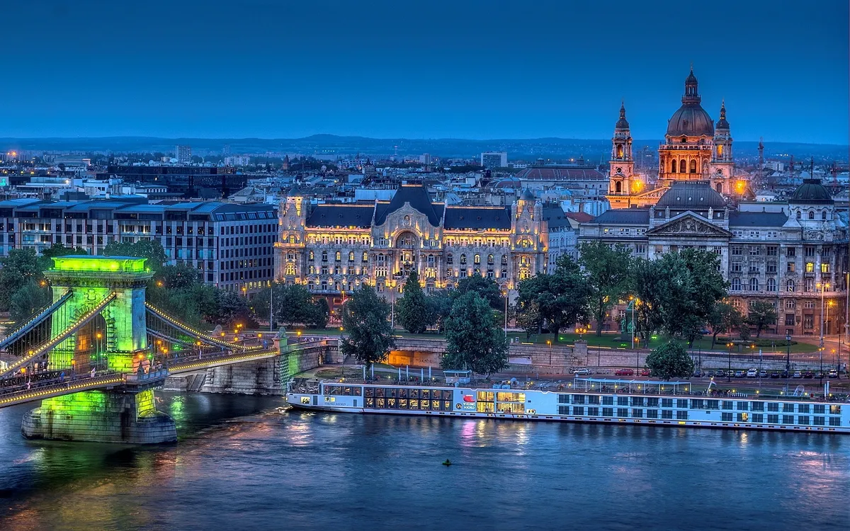
Once called the “Queen of the Danube,” Budapest has long been the focal point of the nation and a lively cultural centre. The city straddles the Danube (Hungarian: Duna) River in the magnificent natural setting where the hills of western Hungary meet the plains stretching to the east and south. It consists of two parts, Buda and Pest, which are situated on opposite sides of the river and connected by a series of bridges.
Although the city’s roots date to Roman times and even earlier, modern Budapest is essentially an outgrowth of the 19th-century empire of Austria-Hungary, when Hungary was three times larger than the present country. Hungary’s reduction in size following World War I did not prevent Budapest from becoming, after Berlin, the second largest city in central Europe. One out of five Hungarians now lives in the capital, which, as the seat of government and the centre of Hungarian transport and industry, dominates all aspects of national life. Tens of thousands of commuters converge on Budapest daily, more than half the country’s university students attend school in the city, and about half the country’s income from foreign tourism is earned there.
Budapest stood apart from the relatively drab capitals of the other Soviet-bloc countries; it maintained an impression of plenty, with smart shops, good restaurants, and other amenities. The dissolution of the Soviet bloc and Hungary’s transition away from socialism brought Budapest new opportunities for prosperity and an influx of Western tourists—along with the stresses of transition to a more Western-style economy. The city, including the banks of the Danube, the Buda Castle Quarter, and Andrássy Avenue, was designated a UNESCO World Heritage site in 1987.
Strategically placed at the centre of the Carpathian Basin, Budapest lies on an ancient route linking the hills of Transdanubia (Hungarian: Dunántúl) with the Great Alfold (Great Hungarian Plain; Hungarian: Nagy Magyar Alföld). The wide Danube was always fordable at this point because of a few islands in the middle of the river. The city has marked topographical contrasts: Buda is built on the higher river terraces and hills of the western side, while the considerably larger Pest spreads out on a flat and featureless sand plain on the river’s opposite bank.
The climate of Budapest is transitional between the extreme conditions of the Great Alfold and the more temperate climate of Transdanubia, with its abundant rainfall. Mean annual temperature is in the low 50s F (about 11 °C), ranging from a July average in the low 70s F (about 22 °C) to the low 30s F (about −1 °C) in January. Mean annual precipitation is 24 inches (600 mm). Winter snowfalls can be heavy, and the temperature may fall below 5 °F (−15 °C), but, on the other hand, heat waves combined with humidity in the summer can make the air oppressive. Flooding in Pest was endemic before the river was regulated in the 19th century. The Danube (blue only in the Johann Strauss waltz) has become heavily contaminated, and air pollution, from which the inhabitants of Buda have largely been able to escape, has afflicted most districts in Pest.
Buda was the kernel of settlement in the Middle Ages, and the cobbled streets and Gothic houses of the castle town have preserved its old layout. Until the late 18th century, Pest remained a tiny enclave, but then its population exploded, leaving Buda far behind. In the latter half of the 20th century, growth has been more evenly distributed between the two parts. Contemporary Budapest covers 203 square miles (525 square km), of which about half is built up. Buda’s hilltops, still crowned by trees; the Danube flanked by three lower hills; the bridges; Margit (Margaret) Island; and the riverfront of Pest lend a remarkable visual identity to the city.
